DPAM
Duane Phillips Architecture & Masterplanning
BOLSHAYA IZHORA, Russia / Russland
| Location: | Bolshaya Izhora, Russia |
| Type: | Resort Town |
| Year: | 2008 |
| Status: | In Progress/Planned |
| Size: | First Phase, 50 Hectares (124 acres) |
| Planning: | as DPZ-Europe with DPZ-Miami |
Located 40 km (25 miles) from Saint Petersburg, Russia, Bolshaya Izhora represents the emerging Russian economy’s investment in its domestic infrastructure and its increased international appeal. Likewise, the growing Russian upper and middle classes are aspiring to strengthen their ancestral connection to the countryside. Bolshaya’s New Urbanist master plan offers an alternative to the recent scattering of commercial centers and gated cottage clusters being built around St. Petersburg’s growing periphery.
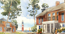
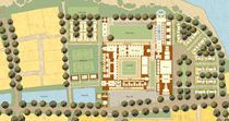
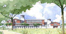
The 50 hectare (124 acre) planned resort village sits on a unique parcel of land with approximately 4km (2.5 miles) of frontage along the southern banks of the Gulf of Finland, and is located to the west of St. Petersburg in an area known for its summer royal palaces, more modest weekend retreats (dachas) and country farmsteads. The village will feature a 200-room five-star hotel with a spa and wellness center and conference facility meant to attract both local visitors and those from abroad. The hotel campus will also feature an entertainment and sport complex, and a series of detached cottages that will blend with the surrounding mixed-use neighborhood’s architecture.
The land features a low lying flat area near the water that was once a sand mining operation and an upland towards the highway consisting of tall pine trees and moderately sloping terrain. The site is known locally as a prime location from which to observe the annual coastal swan migration.
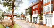
The master plan consequently incorporates a more geometric grid of smaller house lots on the flat land with many streets and pedestrian paths leading to a public promenade along the Gulf, while the upland accommodates the larger homesites and a more organic network of topographically responsive streets. Bisecting the two neighborhoods and perpendicular to the Gulf is a Main Street that acts as a spine, connecting an arrival square off the highway to a town square at the center of the village, and ultimately to a hotel forecourt plaza. Secondary east-west streets weave through the village and link the potential marinas at either end.
| Lage: | bei St. Petersburg, Russland |
| Typ: | Ferienresort |
| Jahr: | 2008 |
| Status: | In Planung |
| Größe: | Erste Phase, 50 Hektar |
| Planung: | als DPZ-Europe mit DPZ-Miami |
Knapp 40km westlich von Sankt Petersburg befindet sich das Grundstück des Projekts Novaja Izhora, das als Beispiel der Investitionskraft der aufkommenden russischen Wirtschaft in die lokale Infrastruktur gilt. So streben die russische Mittelklasse und höhere Schicht zur selben Zeit, gleich ihren Vorfahren, wieder ein Leben auf dem Land an. Der Masterplan, gestaltet nach den Prinzipien des New Urbanism, bietet eine angenehme Alternative zu den jüngsten Stadtentwicklungsprojekten in Form von Gewerbeparks und eingezäunten privaten Wohngebieten rund um St. Petersburgs Peripherie.
Das 50 Hektar große Resort befindet sich auf einem einzigartigen Stück Land mit einem ca. 4km langen Strand entlang des Golfes von Finnland und einer außergewöhnlichen Lage, die für den ehemaligen Sommersitz der Zarenfamilie, Wochenend-Datschen und malerische Gehöfte bekannt ist. Das Resort wird mit seinem Fünf-Sterne-Hotel mit integriertem Spa- und Wellnessbereich sowieKonferenzräumen Besucher von fern und nah anziehen. Das Hotelgelände wird außerdem einem Unterhaltungs- und Sportkomplex sowie einer Reihe von Bungalows Platz bieten, die sich durch ihr Design nahtlos in die funktional gemischte Struktur der Siedlung einfügen werden.
Die Umgebung besteht aus einer flacheren Region in Wassernähe, die früher für die Sandgewinnung von Bedeutung war, und einer höheren, von Pinienbäumen gesäumten Region in Richtung Westen. Daher sieht der Masterplan für die flache Region ein eher geometrisch veranlagtes Flächenraster vor, mit kleinen Grundstücken und einer Vielzahl an Straßen und Gehwegen, die in Richtung einer öffentlichen Promenade entlang der Küste führen. Die höher gelegene Region wird durch ein organisch geschwungenes, der Umgebung angepasstes Straßennetz und großzügig geschnittene Grundstücke charakterisiert.
Im rechten Winkel zum Golf und so die Wohnquartiere halbierend, verläuft die Hauptstraße und verbindet einen Platz am Zugang der Siedlung, über den Stadtplatz im Zentrum mit dem Vorplatz eines Hotels an der Promenade. Seitenstraßen verlaufen in Ost-West-Richtung in regelmäßigen Abständen quer durch die Siedlung und verbinden dadurch mögliche Yachthäfen mit dem Stadtinneren.


