DPAM
Duane Phillips Architecture & Masterplanning
SKOPJE, Macedonia / Mazedonien
| Location: | Skopje, Macedonia |
| Type: | Conversion of Military Base |
| Year: | 2007 |
| Status: | In Progress/Planned |
| Size: | 127 Hectares |
| Business Park: | 167,000 sq.m. |
| Residential: | 511,400 sq.m. |
| Retail Center: | 170,400 sq.m. |
| Golf Course: | 127 Hectares |
| Planning: | as DPZ-Europe |
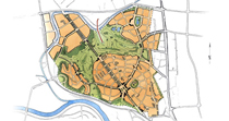
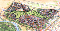
The 127 hectare site is located to the north-west of the city center, bounded by a major motorway to the west, the river to the south, a new bye-pass road to the north, and existing settlements to the east.
The site slopes from two major hills in the south to a relatively flat area in the north. In order to purchase the land, the client needed to show the Macedonian Government what he intended to build on the site. A four day mini-charrette was organized, and a variety of options were explored.
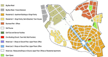
The client decided for a mixed-use proposal, with big-box retail in the north-west at the junction of the bye-pass road and the motorway, an office park to the north-east along the bye-pass, and housing to the south nearest the city center. The housing is designed as two hilltop villages, the largest containing a small commercial center of shops and businesses that provide the daily needs of the residents (bakery, butcher, café, restaurant, etc.). An 18 hole golf course is located between these areas and serves to unite them into one unique community.
The client presented the proposal to the authorities and was awarded permission to purchase the property. Presently, the official Development Plan is being produced by the authorities on the basis of this proposal. It is foreseen that once the purchase is completed, a full charrette will be held to design the property in detail.
| Lage: | Skopje, Mazedonien |
| Typ: | Mixed-Use Siedlung |
| Jahr: | 2007 |
| Status: | In Planung |
| Größe: | 127 Hektar |
| Planung: | als DPZ-Europe |
Im Nord-Westen der mazedonischen Hauptstadt Skopje befindet sich das 127 Hektar große Gelände der geplanten Siedlung. Im Westen begrenzt eine der Autobahn das Gebiet, im Süden der Fluss Vardar, im Norden eine neu angelegte Umgehungsstraße und im Osten begrenzen bereits existierende Siedlungen das Gelände.
Das Gebiet fällt von Süden nach Norden ab und verläuft sich dann in einer relativ flachen Ebene, wodurch den Bewohnern auf den Hügeln im Süden eine hervorragende Sicht geboten wird. Um das Gelände aufzukaufen, musste der Auftraggeber der mazedonischen Regierung einen Vorschlag zur geplanten Bebauung machen. Eine vier Tage dauernder Mini-Charrette wurde abgehalten, um mögliche Optionen zu entwickeln und zu diskutieren. Das Ergebnis war ein Entwurf einer funktional gemischten Siedlung. Ein Big-Box Retail Center im nordwestlichen Sektor, direkt an der Kreuzung der Umgehungsstraße und der Autobahn sowie ein Gewerbegebiet am nordöstlichen Rand der Umgehungsstraße, und Wohnquartiere im Süden und Zentrum der Siedlung wurden entworfen. Die Wohnquartiere wurden als zwei separate Wohngebiete auf den Hügeln entworfen.
Besondere Beachtung erhielten die Überreste eines römischen Aquädukts, welche nach sorgfältiger Planung in die Siedlung integriert wurden. Am tiefsten Punkt der Topographie fungieren kleinere Gewässer als Regenrückhaltebecken und bilden zusammen mit den Teilen des Aquädukts attraktive Erholungsorte im sowie am Rand des Businessparks.
Zurzeit befindet sich der offizielle Bauplan auf Grundlage des entworfenen Masterplans in Bearbeitung durch die zuständigen Behörden. Nach Kauf aller Grundstücke wird eine umfangreichere Charrette abgehalten werden, um noch fehlende Details des Projektes zu entwerfen.


